
It’s been an interesting year… We ended last season on a high with some big GT we caught late in the season and also a fantastic top-water Yellow Fin Tuna bite. We finished off our trips with clients by early May 3013 and headed back to the mainland for a well deserved break. We soon were off on exploratory trips down in Sri Lanka where we had some phenomenal fishing.
Meanwhile in the Bay of Bengal the monsoons were in full swing. We normally see a couple of depressions in the bay which develop into full blown cyclones, but this year was to be different…. a lot more intense. The first one was Cyclonic Storm Mahasen in early May 2013. The storm's huge cloud mass also brought unsettled weather to Sri Lanka, Thailand, and southeastern India. Severe storms in India and Sri Lanka were responsible for at least 16 fatalities and significant damage. Mahasen finally struck Bangladesh in a weaker state and caused less damage than was anticipated.
We then had a series of low pressures developing in the Bay which all eventually dissipated over the Indian Maniland between the end of May 2013 till the end of August 2013. Parts of India and Bangladesh received huge amounts of rain leaving thousands homeless and huge amount of devastation to crops and homes due to inundation.
The next tropical depression formed along the Gulf of Thailand on October 4, over the Andaman Sea and adjoining Tanintharyi region. The IMD upgraded the storm to a deep depression, and subsequently a cyclonic storm, naming it Phailin. Rapid intensification ensued, and Phailin strengthened into a Very Severe Cyclonic storm on October 10. Phailin made landfall close to Gopalpur, Odisha in the evening hours of October 12.The cyclone prompted India's biggest evacuation in 23 years with more than 550,000 people moving up from the coastline in Odisha and Andhra Pradesh to safer places.
On 17th November 2013, the remnant energy of Tropical Storm Podul contributed to the development of a trough over the Bay of Bengal, located near the Andaman Islands. The India Meteorological Department (IMD) upgraded the storm to a depression and a couple of hours later, the IMD upgraded it into a Deep Depression, as the storm continued to intensify.The storm was then named Helen, which continued to intensify into a Severe Cyclonic Storm the following day, reaching its peak intensity of 100 km/h (62 mph) with a central pressure of 990 mbar. Helen made landfall south of Machilipatnam, Andhra Pradesh and rapidly deteriorated into a deep depression. A total of 11 deaths have been reported in incidents related to Helen.
A low pressure area formed over the South China Sea and on 23rd November 2013, it crossed to the Andaman Sea and gradually intensified. Moving at over 08 knots, the system gradually intensified over the next 24 hours. Lehar made it's first landfall south of Port Blair, Andaman and Nicobar, early on November 25. Lehar continued to track in a westerly direction and early on November 26, the IMD upgraded Lehar to a Very Severe Cyclonic storm. Meanwhile, they have warned the coastal districts of Andhra Pradesh and Odisha of heavy rainfall and strong winds.

Above a satellite image of Lehar just after it had crossed over Port Blair in the Andaman Islands.

Above a map of wind speed and wind direction.

The predicted track of Cyclone Lehar over the Bay of Bengal after crossing over the Andaman Islands on its way to the Indian mainland.
The cyclone affected the Andaman Islands with heavy rain and gusts of wind. Lehar caused flooding, land slides, road blockage, uprooting of hundreds of trees and damage in buildings. In Little Andaman, more than 2000 people were evacuated. In the nearby Havelock Island, about 1500 persons got shelter in the panchayat community hall. On 25th Novemeber. Mayabander and Port Blair recorded heavy rainfall of 243 mm and 213 mm respectively in 24 hrs as the Cyclone made landfall close to Port Blair. Port Blair recorded 110 kmph with gusts upto 130 kmph. Port Blair-bound flights from Chennai were cancelled. Luckily there was no loss of life here but the devastation was quite widespread. We've just got our electricity back along with a limping internet connection.

View of the bay the evening before the day the cyclone struck. We initially had some spectacular skies with clouds racing in an anti clockwise circulation with flashes of lightning lighting up the skies.

A view of the Chatham Sawmill in the pouring rain. Luckily this island provided us with cover during the worst part of the cyclone which raged for about an hour and a half.

A view across the bay before the power went out for the night and for the next 36 hours. Most of the main power lines were knocked out by falling trees. The Fire and Electricity Departments worked over time and under trying conditions to get power supply resumed.

On the morning of the cyclone, we had our boat Rampage anchored behind Chatham Island for a couple of hours as it was the only lee we could find. Normally we’re struck with winds from the east, but this time around the winds were from the West. The western winds caught many fishermen off guard and led to many smaller boats sinking in the bay. At the jetty where our boats are moored over 15 boats, wooden and FRP were lost in under a hour. Damage to boats was extensive in other parts of the Port Blair harbour.

Emergency services in action, clearing roads of many trees that had come crashing down during the cyclone. Access to the main part of Port Blair was cut off for most of the day as trees were being cleared. Many low lying areas were inundated with houses and vehicles being submerged.

Coast Guard boats heading out just after the worst bit of the cyclone crossed over Port Blair. Over two dozen fishermen went missing and almost all of them were rescued by the Coast Guard and Police. There are still reports of a couple of smaller wooden craft missing with an estimated 9 people who still have not returned.
Now that the worst has passed we know this was the last of an unusually long chain of depressions across the Bay of Bengal. Sea conditions have quickly returned to what they were with the wind being slight. This long chain of events could well be the effects of global warming. Cyclones typically lower sea surface temperatures and in this part of the world are a part of life.

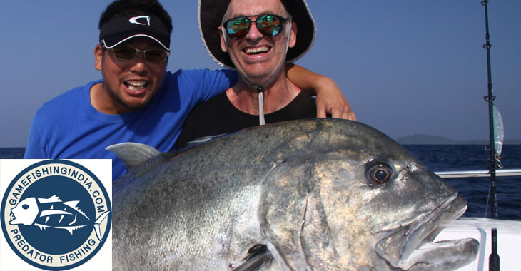
We now know like everyone does that the fishing only improves after a storm. We are out fishing again soon and our catch reports will be up as we complete fishing with groups at some of our favourite GT spots like the one above.

Nothing quite like looking into a mirror calm sea to spot some monster Yellow Fin Tuna swimming under the boat after a school of bait-fish!!
Team GFI
No comments:
Post a Comment
Registered Users can now post comments, thank you for your post